Friday, December 19, 2014

Winter Solstice SaddleSore 1,000

On Sunday, December 21st, the winter solstice, I will ride another IBA SaddleSore 1,000 miles in under 24 hours to qualify for the Four Seasons certificate. 

Full SpotWalla MapsSPOT Gen3 and BubblerGPS (pictured below)


The winter solstice occurs at 5:03 PM for us here in the Central Time zone.  So, in the true spirit of the IBA Four Seasons challenge I will be riding my motorcycle during the exact astronomical moment the northern hemisphere of the earth is tilted the furthest away from the sun.

Epilog:  The riding was great.  The motorcycle performed flawlessly.  There were no close calls.  As usual, the FLIR PathFindIR thermal imaging system made riding dusk till dawn less stressful and much safer.  I am liking the new Garmin 590LM motorcycle GPS.  My preparations for the 2015 Iron Butt Rally are coming together nicely. 

Sun, Dec 21:  I will get my starting DBR (dated business receipt) at 0500 before ride east to the Sabine Turnaround for the beginning of I-10 at the Texas Information Center.  First stop will be just west of San Antonio for fuel.  Then Fort Stockton, Anthony and finally finishing in Van Horn, maybe Alpine..  

The ride from Orange was a little chilly.  By the time I got to Houston the sun was coming up but it was still cloudy.  Traffic was light through the big city and I made good time.  By the time I got to the Loop 1604 turn off to go around the northern part of San Antonio the clouds had landed producing wet riding.  No rain, just wet fog with good visibility ahead.  That cleared up by the time I got to my first pit stop at the Ralph Fair exit west bound out of San Antonio. 

Just past the Kerr County line the speed limit picked up a bit...to 80 MPH.  The clouds broke and the sun was shining between Ozona and Fort Stockton, my second fuel stop.  By this time, early afternoon, the sun had warmed things up to a cozy 65f.  It was clear riding all the way to Anthony and my third fuel stop.  Just a couple hundred miles left to complete the ride but I decided to finish in Alpine instead of Van Horn.  Alpine is a much more friendly place to stay and it's closer for the ride home in the morning.

Well, three down and one more SaddleSore 1,000 to complete the Four Seasons requirements. 

Sat, Dec 20:  Started from home around noon heading for the starting location in Orange, TX.  I will be using the same route I used for the Texas I-10 Solstice Day Ride and Fall Equinox SaddleSore 1,000 rides. :  Orange - Anthony - Van Horn.  It's I-10 all the way and on the weekend.  The weather is going to be chilly but clear for the weekend so, I will be sure to take along my heated electric riding gear. 

The ride to Orange was smooth and uneventful.  Except for a little traffic jam through Houston.  Five lanes scrunching down to one lane due to construction.  Got to Orange about 17:10 and stopped by Subway for a sandwich before going to the Super8.  I got the desk clerk to witness my IBA form so I'm ready to head out first thing in the morning. 


This will be my first "on the clock" ride using the new zumo 590LM GPS.  Back in October while riding the Big Tex Rally my backup zumo 220 died.  So, I purchased the Garmin's newest motorcycle GPS with all the latest bells and whistles, including the built in tire pressure monitoring system, TPMS.  At first I was using the 590 as the backup unit but liked its feature so much, and the new user interface, I decided to swap the units around.  I spent some time farkling the new setup for the 590 and 665 zumos to get the mounted as stable as possible.  I used a piece of 2 inch by 1/8 inch aluminum stock to fabricated supporting mounts.  This gives each GPS unit the anti vibration and stable mounting.  The "FarkleBar" I purchased at the IBA International Meeting back in August provided the ideal mounting platform to provide a clean setup. 

Saturday, October 11, 2014

Big Tex Rally

I am participating in the 80 hour Big Tex Rally as a training ride for the 2015 Iron Butt Rally.  The BTR starts in Albuquerque NM on Wednesday morning 10/15 and ends on Saturday 10/18 in Cedar Hills TX.  Click on the camera icon to see the BubblerGPS Pro pictures.

Full SpotWalla Maps:  BubblerGPS and SPOT Gen3


Saturday, 10/18:  The finish of the rally is at 1800 in Cedar Hills just south of Dallas.  I got to the 44M pistol range bonus right on schedule.  Shot my rally flag three times with a Springfield Armory 45 ACP then off to do cleanup bonus hunting on the way to the finish.  I got another 2,000 points before reaching the finish.  On bonus was to pick up a six pack of Shiner before arriving at the hotel.  I really enjoyed getting off that bike and washing the road off of my throat with a cold Shiner!  I didn't check into my room as I wanted to get the scoring process completed.  The BTR uses self scoring method where each rider records their successful bonus list, in order and supplies all the documentation and photos to the scoring team for verification.  I didn't finish in the top 10 but was happy with the ride.  It was great training.

Friday, 10/17:  I planned a more aggressive route for leg 2.  There are a string of big bonuses out near Big Bend and a couple of hefty ones along the way.  My goal is to arrive out at Chisos Basin in Big Bend NP around sunset.  But first I had to ride to Laredo and Del Rio, where my mother was born.  In Del Rio my bonus task was to secure a package of "Horny Goat Weed" along with a dated business receipt showing where and when in Del Rio I purchased it.  I found what I was looking for at a local liquor store for $.99.  On to Big Bend where I got there a little after sunset.  The next stop was to sign the refrigerator of Iron Butt legend Voni Glaves in Terlingua.  She is working on her second 1,000,000 documented miles by motorcycle.  She and her main squeeze Paul greeted me with true West Texas hospitality.  Off to the next bonus before I would seek some rest.  It was the large arrow at the entrance to the Fort Davis Boy Scout Camp about 10 miles off of the main highway.  I'm riding at night in West Texas and the critters are everywhere. My FLIR PathFindIR inferred thermal imagery critter detection system was clearing the way ahead.  God, I love that farkle!  I wanted to reach the shooting range at Pete's Pasture by around 1130 the next morning so after the Boy Scout bonus I rode to Ozona arriving around 0130.  There I set my alarm and camped out on the deer corn pallets lining the front of the Stripes convenience store.  Yes, I checked into the Iron Butt Motel. 

Thursday, 10/16: The Texas Capital rotunda bonus is a mandatory stop before reaching the Galveston checkpoint.  I maximized the Wednesday night rest bonus for 7,200 points.  And, there is another rest bonus for me when I reach Galveston.  The checkpoint closes at 2200.  By that I mean the rally book for the second leg will be available from 2000 - 2200 only.  Those that arrive after the 2200 close will have to wait till 0500 on Friday to get their leg 2 bonus listing.  I did room services while I planned the next leg.  Took a shower, loaded up the GPS and hit the sack. 

Wednesday, 10/15:  Let the ride begin!  No time to do any blogging while I'm on the clock.  Check out the map to see my course as I collect the bonus points along the way to Galveston.  The weather was great today and the riding was even better.  I chose a southern route towards Galveston that had enough points to exceed the minimum for the leg by 130%.  Probably not enough to put me in the top 10 but I 'm not shooting for that kind of ride anyway.  My goal for the Big Tex Rally is to practice for the 2015 IBR.  I'm looking for consistent ride pace, good bonus task execution and accurate documentation. 

Tuesday, 10/14:  The parking lot at the Ramada is filling with motorcycles  I'm not sure of the count for the 80 hour Big Tex Rally but I think there will be about 30-40 riders departing from Albuquerque on Wednesday at 0900.  Today, I'm going to do pre rally tasks and get ready to receive the rally pack this evening.  Then the fun begins....transforming the raw rally data into a configuration that will help me select the route to Galveston.  I have to assign point value and availability to the published waypoints.  Then select a string of locations that get me to the mandatory Galveston checkpoint on time.  The method I use to accomplish this task can be found on my Ride Planning blog page.  Check it out if you're interested.

Monday, 10/13:  Departing home for the 700 mile ride up to Albuquerque.  A thunderstorm was blowing through as I was leaving,  I was at the bottom of the squall line so it only took a hour to ride out of it.  On the other side it was head wind all the way to Roswell.  Somewhere along the way the right speaker of my headset knocked out.  How irritating!  It always seems to happen on the way or during a planned event that these issues happen.  I pulled into a Walmart and bought a set of ear buds.  Now, all I have to do is to learn how to keep them in place.  Maybe duct tape.....hummmm.

Sunday, September 28, 2014

The Grand Tour - East

The George A. Wyman Memorial Project is dedicated to keeping alive the story of Wyman's epic across America by motorcycle from San Francisco to New York City - May through July, 1903.

Back in August I rode all the points along the way from San Francisco to Cheyenne to validate the locations for the George A. Wyman Memorial Grand Tour - Rider's Guide.  Now, it's time to verify the eastern points along the way from Cheyenne to New York City.   I will be visiting each point to verify my virtual research and mark the final position for the Grand Tour locations.  The map below is of my BubblerGPS Pro track feed.  The camera icon means there is a picture attached to the map tag.  I will also be blogging along the way providing updates as they develop.

See full BubblerGPS and SPOT Gen3 SpotWalla maps 


Sat, 10,4:  The goal today is to get to Manhattan.  I will be doing some research at the main library in Albany looking for the location of what GAW termed the J.W. Anderson agency where he did some repairs.  I've had good luck with the 1903 City Directories in other locations so I'm hoping to score a good location for the Albany spot. 

Another very wet morning.  It did not stop raining till I get to Manhattan.  But, before that I managed to get to all the points along the way.  I didn't follow the scenic route that GAW took.  He actually used the Erie Canal towpath most all the way from Fairport to Albany.  In Cayuga I was able to identify the spot that the Mansfield Hotel stood in 1903.  That was the only hotel in the town at the time.  In Albany a quick trip to the main public library paid off with the street address of the Anderson bicycle location at 407 Madison Ave.

The trip down Broadway in NYC was not much fun as you might expect.  But I was able to document the two spots north of the 1904 Broadway finish.   The first was in Kingsbridge where GAW entered NYC according to the report for Bicycling World and Motorcycle Review and the spot where "Josh" interview GAW at Broadway and 195th street.  At the 1904 Broadway location I was able to get the card for the building owners to contact about mounting a GAW Memorial Plaque.  It was Saturday and none of the decision makers were around.  Same at the Harold Square Hotel.  I'll give them a call after I get back home to Wimberley on Monday.

With the completion of the GAW Memorial Grand Tour East validation ride I have successfully documented every point along the way that GAW rode to, save the ones not accessible by road (railroad sidings in remote areas).  I was able to document and preserve for future riders all the significant landmarks, locations and in some cases actual buildings and rooms GAW visited at the points along the way from San Francisco to NYC.   Not since 1903 has a motorcyclist ridden to the George A. Wyman points along the way and documented the experience.

Fri, 10/3:  Starting in Elyria then on to Cleveland.  I will have to wait till 10:00 for the main library to open as I want to find the location of the "Ohio Oldsmobile Company" that GAW purchased oil from when he stopped there for the night.  It was nice and dry when I left for Cleveland.  I got there early and had to wait about an hour before the central library opened up at 10am.  The rain was moving but it hadn't started yet. By the time I looked up the address to the Ohio Oldsmobile Company location it had started to rain.  It rained all day.  Not a lot of rain but the roads were wet and it made for less than optimal riding.  Enough whining about the weather, it's good training for the Iron Butt Rally. 

So, had a good day visiting the GAW points along the way.  I did some research at the Angola library but that didn't turn up anything useful as far as bicycle shop locations or hotel locations.  I stopped at the E.R. Thomas building in Buffalo where GAW had his bike front forks repaired.  I wanted to get the information as  to who to contact regarding putting a GAW memorial plaque on or near the building.  It was close of business time at the Rich Food plant, owners of the ER Thomas building, and all I got was a number to call on Monday.  I stopped for the night after visiting Fairport.  GAW followed the Erie Canal for a lot of the way between Rochester and Albany.  Maybe if the weather is nicer tomorrow I'll do that scenic route.  Right now my gloves are drying out over a low heat.

Today, October 3, is the anniversary of the Battle of Mogadishu in 1993 -- lest we forget those who served - Black Hawk Down

Thu, 10/2:  On to the Chicago area then east to Indiana and Ohio.  My riding goals are to get well into Ohio before stopping for the night.  It was wet today with very little rain, mostly sprinkles.  But the roads stayed wet all day.  I have been riding at near rally pace to push through to my daily goals for locations.  No new discoveries today just the usual adjustments to pick a better point location over virtual plotting.   I did stop at the Ligonier Historical Society to let them know about GAW and maybe get their help doing some research at the local level.  GAW spent the remained over night RON there on June 24th.  There are many of the circa 1900 buildings on Main Street and the town is restoring many other structures.  I'm hoping that a scan of the newspapers of June 24-30 might turn up an article on GAW that may cite the hotel he stay while in town.

It is fun riding through all the old town centers with their vintage buildings beautifully restored and still thriving businesses.  Some, sadly are virtual main street ghosts of yesteryear.  But, the Grand Tour in the mid-west is better than I thought it would be.  Riding between the stops along the way one gets a sense of what GAW may have seen.  Every old house, barn or downtown that catches my eye might have caught GAW's too as he rode his motorcycle along the dirt roads.  This is turning out to be a fun event.  Much harder than I expected at the pace I'm riding.  But very challenging and rewarding.

Wed, 10/1:  Today I hope to get all the way through Iowa and most of Illinois before I seek out a hotel room for the night.  First stops today are in Omaha at the Flesher Bicycle Shop location and the UPRR Express Office.  It was raining somewhat when I started this morning.  Went to the three locations in the Omaha area then headed east.  My goal was to get through Iowa and well into Illinois before stopping for the night.

In Marshalltown, where GAW spent the night on Monday, June 15th, 1903, I wanted to zero in on the location.  So, the first stop when I get to Marshalltown was to the central library to check the 1903 City Directory.  It was on microfilm and I quickly discovered there were 7 hotels in town in 1903.  The one I was looking for was run by a "widow and her two son" according to GAW.  The person at the library Information Desk did not have that information but sent me to the local Historical Society.  There, I met Michelle Roseburrough and explained what information I needed.  She was fascinated by the GAW story and the connection to Marshalltown.  She pulled out the big book of businesses, circa 1900, and quick zeroed in on the Stoddart Hotel at the corner of Main and southwest corner of 3rd Ave.  In the description in her big book of businesses was the remark, "It had been conducted as such (hotel) by the present owners, Mrs, Ella Stodart and her tow sons, Messers Earl and Harry Stoddart, for the past four years."  Boom!  Sadly, at the building location is now a parking lot.  She is going to scan the picture of the hotel and the description and email it to me.

In Cedar Rapids I met with Karl, the owner of Hall Bicycle Company where GAW repaired his front forks and worked on all the other problems when he arrived in town on Tuesday, June 16, 1903.  Karl was very excited about getting a GAW Memorial plaque for his business.  We posed for a picture at that location in Cedar Rapids.  Check it out. 

I stopped in Yorkville, IL for the night just outside of Aurora IL.  Riding is good and the George A. Wyman Memorial Grand Tour is turning out to be quite a challenging ride.  The route is excellent and follows the Old Lincoln Highway or US 30 most of the way.  Once can tell it's the route GAW used because it hugs the railroad most of the way.  It's usually in sight of the road and each location he mentions along the way includes the rails. 

Tue, 9/30:  Going to gas up first thing in the morning then ride the 100 miles north to Egbert WY, my first stop along the way of the Wyman Grand Tour - East.  Then the long trek east hitting each in turn.  I expect to get through all of Nebraska and most of Iowa before stopping for the night.

Got almost all the way through Nebraska today.  Was raining as I was riding into Omaha for the night.  Seems it was the same weather front I rode through yesterday heading up to Egbert.  At any rate it was fun riding along the route GAW took to each of the Nebraska points along the way.  When I got to the Paxton point some contractors were inside the circa 1900 Paxton Station renovating its insides.  I dropped off one of my GAW Memorial Project cards for the owner to contact me if interested in getting a plaque mounted on the outside of the build.  Hey, how about at the "Motorcycle Parking Only" spot in the parking of the new eatery.  Now that would be cool.

On Monday morning, June 8, 1903, GAW had to hold up in the Paxton Station for three hours to wait of a bad thunderstorm. 

Mon, 9/29:  Leaving the suburbs of Wimberley for Egbert WY, the next stop of the GAW Grand Tour.   I hope to be north east of Denver before I stop for the night.  Then up bright and early to get to Egbert first thing in the morning.

The weather was great all the way though Texas and into Oklahoma.  Sunny, with temperatures in the high 70s.  Thunderstorms were predicted in eastern Colorado and sure enough there was a monster cell just to the west of me as I was riding north along US287.  I checked my weather radar on my GPS and my route put right through the worst part of the storm as I turned northwest at Kit Carson.  So, I pulled over into a quaint cafĂ© and had supper to wait out the storm.  It was a thin front and moved through in about 30 minutes.  Behind the front the temperatures dropped to the low 50's so I put on my electric jacket liner, plugged in and headed up to Fort Morgan for the night. 

Pre-Ride Research:  I have been spend lots of time doing virtual research on each of the Wyman points along his route.  Some of this research has developed new information regarding his epic journey that was lost to history.  For example, GAW stopped in Cedar Rapids to repair.  He identified it as "a bicycle store on Second Avenue."  Well, turns out there was only one bicycle shop on Second Ave in Cedar Rapids on June 16, 1903, that of Ed Hall, The Hall Bicycle Company, at 108 Second Avenue.  Hall Bicycle is still in business today!   It is now located at 419 Second Avenue but the owner can trace the operation of the firm back to Ed Hall.  I have contacted the current owner and he has agreed to mount a George Adams Memorial plaque on his building at the current Hall Bicycle. 

Sunday, September 21, 2014

Fall Equinox SaddleSore 1,000

The fall equinox is Sep 22 9:29 PM CDT.  I am riding my second leg of the Iron Butt Four Seasons challenge: complete at least 1,000 miles in under 24 hour on each of the four celestial events.

Full SpotWalla MapsSPOT Gen3   BubblerGPS Pro (pictured below)


Monday, 9/22:  Departed the motel at around 5:25 for the Exxon station.  Topped off the tank and headed to the Sabine River turnaround at Exit 880 on I-10 west bound.  It's the first exit after crossing over from Louisiana.  Marked a SPOT and headed out. 

Traffic through Houston was not as bad as I expected it to be at 7am.  First fuel stop was on the west side of San Antonio.  It was the same place I stopped during the Summer Solstice ride back in June.  After Fort Stockton the weather turned wet and it rained of and on all the way to near El Paso.  Traffic through El Paso flowed real well at 5pm and it was a breeze to Anthony.  Got gas and a quick coffee with banana nut muffin before departing east.

I wanted to be riding at the official time of the fall equinox event at 9:29 PM CDT.  So, instead of stopping in Van Horn at just over 1,017 miles I rode to Fort Stockton for 1,133 miles.  I arrive just before 10pm, well after the official equinox time. 

Sunday, 9/21:  Left home for Orange.  I stay at the Days Inn for about $60.  It is right around the corner of an Exxon station with good receipts at the pumps.  I checked in and got Veronica, the desk clerk, to witness my IBA form.  Things went very smooth.  I turned in for the night.

I will be riding the same route and time table of the Texas I-10 Solstice 'Day Ride' I did back in June.  Starting in Orange at 6:00, riding I-10 to Anthony, turn around and finishing in Van Horn. 

Since the 22nd falls on a Monday I expect some traffic delays through Houston.  Also, the equinox for the CDT zone occurs at 9:29 PM I will make sure I am still riding at that time to remain true to the spirit of the Four Seasons event, even though it is not necessary by IBA rules.

Sunday, August 10, 2014

The Grand Tour - West

This Hard Riding Adventure is all about The George A. Wyman Memorial Grand Tour ride.  I've been working on the Grand Tour Rider's Guide and have a section for each of the GAW waypoints from San Francisco to Cheyenne.  Starting on Wednesday afternoon I'll be visiting all the points along the way to verify the particulars.

Follow along via the BubblerGPS Pro track below or the full SpotWalla Map.  Watch for the pix at points along the way.

After reaching Cheyenne I'll be turning south to Denver to attend the Iron Butt Association International Meeting.  I'm scheduled to give a "dinner talk" about George and his long distance riding accomplishment.  Should be fun!

Tue 8/19:  Fort Steele was the first point along the way today.  Not too far from Rawlins it's right off of I-80.  The park hours are 9am to 5pm during the summer and I got the just as the caretaker was opening up....at 8:20am.  I was able to take a couple of pictures of the bridge foreman's building and the point were GAW may have crossed the river via the old immigrant trail.  From there it was onto Walcott where GAW remained overnight.  I couldn't find the hotel but there were lots of other buildings in the vicinity of the RR. I rode up to Medicine Bow passing several of the other points not accessible by road.  Medicine had a nice depot turned into the local museum.  Headed south to Laramie to the Lovejoy Bicycle Shop location.  Then over the ridge to Summit then down towards Cheyenne.  I was looking for the place where GAW got stuck and helped by SC Schrader (Shaver).  No luck, the whole ranch are had been subdivided into ranchettes.  I got to the Cheyenne UPRR Depot where GAW checked his motorcycle then I headed to the central library to look up where GD Pratt's bicycle shop was located.  Got a 1902 city directory and found it no problem.  The name of his establishment was the Grainger Cycle Company at 1711 Capital Avenue....no the parking lot of the Wells Fargo Bank.  Dang.....

I left Cheyenne for Denver and the Iron Butt Association International Meeting.

Mon 8/18: Across Wyoming for the next two days.  The riding out of the Salt Lake valley was great.  First of the points along the way was Weber Canyon.  The narrow gap that pilgrims traveled to the Salt Lake basin.  I was following George's tracks going the other way....east!  Got to Echo and checked out the Pilgrim Rock, what's left of it and the Weber pony express location.  Rode past the Devil's Slide rock structure that GAW mentioned....still there.  By the time I got to Evanston it was time for another cup of coffee.  But first, a visit to where GAW slept on a chair for the night.  The Evanston RR Depot, built in 1900, is still standing and completely restored.  I met with Key Rossiter of the Uinta County Museum and she gave me a tour of the Depot as it was closed to the public.  I told her the GAW story and she was very interested in all the details.  Seems her Facebook fans love all this history stuff.  But, anyway, the Depot is divided into two sections, men to the left, woman to the rights. That narrows down where George slept on the chair in the depot.  How about that, I got a picture of the actual room George did an "Iron Butt Motel" stay.

In Granger, where GAW stayed for the night, I was able to locate the building that was the Hotel.  It was donated to the school district in the 1920's but the basic hotel building is still there and intact.  I visited all the points along the way except Spring Valley and Altamont tunnel.  There was no access to either of these except on foot.  At Point of Rocks I spoke with Paul Varley, who's family have been in the area for a hundred years.  The Varley's had a thriving business in Bitter Creek.  I asked him about it and if the road was good.  It was and I went.  Not much circa 1903 structures remain.  Just the water tower and an old section house near the tracks.  But I got the location marked and I was on my way.  Wamsutter was another of those places that have seen better days.  But I did go to the old part of the town and took pictures of the road that GAW rode through on Monday June 1, 1903.

I wanted to find the Continental Divide monument that GAW visited but it had since been replaced and moved closer to I-80.  But, it was fun searching for it.  I stopped in Rawlins for the night.

Fri 8/15:  Over the top of the Great Salt Lake and on to Ogden.  Just five stops today.  Two of these, Tacoma and Terrace, will take me off the paved road.   Both Tacoma and Terrace have BLM information signs on UT 30 where any motorcycle can get to without issues.  But, I'm riding a Dual Sport motorcycle designed for off road riding.  Tacoma was easy being just about a mile off the paved road.  The gravel road out to the Tacoma station sight was hard packed and well graded.  The only indication at the site is a BLM sign with the word "Tecoma" on it and the remains of the Tecoma station foundation  Still is was great to get to the spot GAW rode through.

Terrace was a bit more of a challenge but the pay off was splendid.  A couple miles off UT30 and I intersected the actual RR bed that GAW rode over. It is straight as an arrow right into Terrace.  It was an incredible experience to be in such an isolated place riding in GAW's tracks.  When I got to the Terrace site it was struned with the remains of the once thriving station complex.  There lots of broken bricks where the RR roundhouse stood and I could see lots of other structural remains.  BLM has two "Terrace" information signs and I took close ups of each.  BLM also produces a map of the Trancontental Railroad National Back Country Byway which traces the old RR around the top of the Great Salt Lake.  I was very early in the day and I decided to follow it around just like GAW.  I got about 8 miles and the road was washed out.  So I turned back to the cutoff to UT 30 and took that route. 

Update:  I learned the Zenda siding location is not were I thought.  So, I'm adjusting the location back to my original conclusion at the RR siding near Pioneer Park in Brigham, UT. 

The last two stops on this leg were the UPRR Express Office where GAW picked up his two tires and a gallon of oil.  And, the LH Becraft Bicycle Shop location just a couple of blocks from the Union Station.  Then I headed to Salt Lake City to stay the weekend.

Thur 8/14:  East over the Sierras and on to Nevada.  What a great ride today.  I managed to get to all the GAW points along the way.  I stopped for the night in Wells, same as GAW, and will do all the Utah waypoints tomorrow.  Check out the pictures at the waypoints on the map above.  I also took lots of other pictures with my camera.  At Donner Summit and Palisade I took pictures of the tunnel GAW had to ride through as he followed the tracks.  All pretty interesting.  The Upsal location is not accessible by road so I put an offset waypoint on the highway.  When I got there, there was no place to run off safely.  So, I'll probably change the task to for information only.

Wed 8/13:  Chilling out at the Beemer Shop. The shock install went great and I was back on the road about three.  I headed up the ferry terminal at Vallejo, where GAW spent his first night on the road.  Check the map for the stops I made along the way. I stopped in Colfax for the night, just like George.

Tuesday:  Since I have all day to scout out GAW points I'm riding to Oakland to visit the final resting place of GAW.  Then cross the bay to SF to visit the SF Ferry Terminal east, Lotta's Fountain and the 1903 location of the California Motorcycle Company to take a picture of what's there now.  At Lotta's Fountain I'm going to identify the possible buildings to mount a GAW Memorial plaque if the political track, to get it mounted on or near Lotta's, doesn't work out. 

The Mountain View Cemetery is beautiful!  Very well run and maintained memorial park in Oakland.  I had an excellent conversation with my point of contact at MVC regarding GAW.  They are in the midst of reprinting all their tour documents, brochures and portfolios.  The committee that makes the decisions about who gets into the Famous People locations meets in September.  They are very keen to include GAW and a memorial plaque somewhere appropriate on the grounds. 

After leaving the paying my respects to GAW I headed over the bridge to San Francisco.  Check out the pictures in the map above.  After I finished in SF I dashed down to Scotts Valley to check into a hotel for the might.  Tomorrow, I'm having my ESA shock redone.  On the way down from SF I got to practice my California "lane splitting" techniques.....so exciting!

Sun & Mon:  Left the Wimberley suburbs at noon.  The plan was to ride to Van Horn and stop for the night. But, by the time I got there the sun was still high in the sky so I rode to Anthony at the border.  The temperatures and winds were good on Sunday all across west Texas.  Got an early start on Monday.  The plan is to get to I-5 in California around sundown.  Riding was good with no traffic or construction issues.  But the temperatures started to hit triple digits around Tucson and stayed hot all the way to Banning CA just past Palm Springs.  Got up to 112f for most of the desert starting at Phoenix through Palm Springs.  I styed hydrated with chilled drink in the Under Armor insulated drink bottle and cool water from my insulated CamelBak Antidote system.  With the quick release bladder/hose connection it makes carrying the bladder into a store easy.  Because the 100oz bladder is flexible it fits under a soda fountain ice dispenser with ease. 

I got to Wheeler Ridge, on I-5 around 2000 local time.  Had a veggie Cantina Bowl and bean burrito from Taco Bell.  Checked into a brand new Microtel for the night and all is well. 

This is going to be a leisurely paced trip but I do have sort of a plan.  I'll be posting the blog along the way, using my usual format, of the most recent posting on top. 
  • Sun 8/10 - Tue 8/12:   Make my way to Scotts Valley, CA
  • Wed 8/13:  Wilber shocks installed on the GSA at the Beemer Shop.
  • Thu 8/14 - Sat 8/17:  San Francisco to Ogden UT  Grand Tour scouting
  • Sat 8/17 - Sun 8/18:  Salt Lake City family visit
  • Mon 8/19 - Tue 8/20:  SLC - Cheyenne Grand Tour scouting
  • Wed 8/21 - Sun 8/24:  IBA International Meeting in Denver
  • Mon 8/25 - Tue 8/26:  Ride home to near Wimberley, TX

Friday, August 1, 2014

The George A. Wyman Memorial Project

Memorial plaque, metal, 11 by 8 Inches, raised letters, picture is a zinc etching

Please see:  The George A. Memorial Project

All the content of the Project has been moved to the link above.  Listed below are the major content of the Project web site.


The George A. Wyman Memorial Project, established August 2014,  is a historical preservation and educational tax exempt non-profit organized under section 501(c)(3) of the Internal Revenue Code (ID 47-3332474)  Snail mail:  The George A. Wyman Memorial Project,  P.O. Box 1728, Wimberley, TX 78676-1728

Friday, July 25, 2014

2015 IBR Goals and Objectives

"A goal without a plan is just a wish." -- Antoine de Saint Exupéry

My goal is to complete the 2015 Iron Butt Rally as a Gold Medal Finisher.  I will strive for a personal best by scoring better than my IBR 2013 16th place position.  

In my opinion, successful Iron Butt Rally riders are those who safely reach the final check point on time and with enough points to achieve their goals.  A rider applies his or her knowledge, skills, and abilities using the tools of the sport, in a balanced way among several interacting performance elements to achieve success. See "LD Riding on the Clock -- An Organizing Framework"

Goal-setting involves establishing specific, measurable, attainable, realistic and time-bounded (S.M.A.R.T.) objectives. Once these objectives have been set they become the gauge by which goal success can be measured. To achieve my goal I have identified specific objectives for each leg of the Rally.  These objectives are based on my analysis of the Ride Pace of previous IBR finishers.  This analysis reveals two significant metrics which help me identify the specific objectives to reach my goals:
  1. Point Spread:  Gold Medal finishers achieve total points above 145% of the minimum to attain Finisher status.
  2. Ride Pace:  Gold Medal finishers have an overall average around 45.0 MPH
Point Spread:  There is no way of knowing the minimum points to be considered a finisher until it is announced just prior or at the start of the leg.  This typically occurs at the opening banquet the night before the start of leg 1.  And, at the 6:00 AM  rider meetings for legs 2 & 3.  When the minimum is announced I can determine the point target (objective).

Specifically, I want to know how many bonus location points I must plan for to reach the 145% target over minimum.  Not all of the points will be bonus location points, or points I earn by successfully reaching a location and document the stop as called for by the bonus listing.  About 20% to 30% of the minimum bonus points can be derived from admin bonuses; tracking, rest, call-in and others.  By subtracting the points of the admin bonus from the 145% over minimum value I can then determine the target amount of location bonus points necessary to achieve the leg goal.  This becomes my bonus point target for the route selection task.  I will select bonus locations with the highest value for the calculated achievable miles and the available time.

Ride Pace:   Normally, I can maintain a 45-48 MPH overall average (Ovg) while riding on the clock.  My moving average (Mvg) varies depending on the geographical area but are generally 65-70 MPH in the western US and 60-65 MPH in the eastern US.  Apply these metrics with the announced leg hours and the rest is basic math.  ReferenceRally Leg Plan Tool -- Profile

Listed below are the planning standards/assumptions  I use to calculate the number of possible bonus locations and bonus location total time for each leg.  Combine the number of bonus locations with the target points for the leg can lead to selecting a route that meets objectives:  145% of leg minimum at a sustainable Ovg around 46 MPH

  • Planning on the Clock:  Zero for Leg 1, 2:00 hours for Legs 2 & 3
  • Fuel Endurance Distance (FED) -- 350 miles of usable fuel range with small reserve
  • Average time per Pit Stop -- 0:10 minutes each
  • Rest hours per 24 hour period -- 8 Hours to earn full value of the Rest Bonus with 6 hours for each remaining 24hr period.
  • Average time per Bonus Stop -- 0:10 minutes each or multiples of 10 min for bonus stops that require a specific amount of time greater than 10 minutes.

2015 Iron Butt Rally Leg Start/End Date/Time -- Starting and Ending in Albuquerque (ABQ) NM

Leg 1:  10:00 MDT 29 Jun, ABQ NM 82 hours to end 20:00 MDT 2 Jul, ABQ NM
  • Route Selection:  0:00 planning on the clock
  • Planning Miles:  3,772 miles = 82:00 Lhrs X 46 MPH Ovg 
  • Moving Time:  55:28 = 3,772 miles / 68 MPH Mvg
  • Pit Stop Number:  10 = 3,772 / 350 FED (rounded up)
  • Pit Stop Time: 1:40 = 10 Pit stops X 0:10 per stop
  • Rest Stop Number:  3 = 82:00 / 24 hours
  • Rest Stop Time:  18:00 = 6:00 standard (day 1), 8:00 Rest Bonus (day2), 4:00 day3
  • Bonus Stop Time:  6:51 = 82:00 Lhrs - 55:28 Mvt - 1:40 PSt - 18:00 RSt
  • Bonus Stop Number:  41 = 6:51 / 0:10 per standard bonus stop
  • Slack Time:  To be calculated after route/bonus number is determined

Leg 2:  06:00 MDT 3 Jul, ABQ NM 60 hours to end in 20:00 EDT 5 Jul, Kingsport TN (EDT)
  • Route Selection:  2:00 planning on the clock
  • Planning Miles: 2,760  (at 46 Ovg)
  • Moving Time: 40:35 (at 68 Mvg)
  • Pit Stop Number:  7
  • Pit Stop Time:  1:10
  • Rest Stop Number:  2
  • Rest Stop Time:  12:00 (4:00 day 1, 8:00 RB 2 day, maybe)
  • Bonus Stop Time: 4:14
  • Bonus Locations:  25 (at 0:10 standard each)
  • Slack Time:  To be calculated after route/bonus number is determined

Leg 3:  06:00 AM 6 July, East US 100 hours to end 08:00 MDT 10 July, ABQ NM
  • Route Selection:  2:00 planning on the clock
  • Planning Miles:  4,500 (at 45.0 Ovg)
  • Moving Time:  69:13 (at 65.0 Mvg)
  • Pit Stop Number:12
  • Pit Stop Time:  2:00
  • Rest Stop Number:  4
  • Rest Stop Time:  22:00 (split among 4 days maxing the RB)
  • Bonus Stop Time:  4:46
  • Bonus Locations:  29 (at 0:10 standard each)
  • Slack Time:  To be calculated after route/bonus number is determined

After the route is selected I will use the computed route miles, computed Mvg, pit stops, planned rest time and number of selected bonus locations to determine the slack time to the checkpoint. 
I fully expect the plan and objectives to be challenged by the operational environment as I ride the leg.  But, these organizing measurements will help me to make better decisions about changes to the plan.  Understanding how the allocation of total leg hours among the various uses aides me in maintaining a consistent ride pace and manage resources.  Once the slack time is determined I will spend it dearly.  I will seek efficiencies doing bonus. pit and rest stops.   I am committed not to purchase bonus stop time with the currency of excessive moving average MPH (speed).  Also, I am determined to get the quality rest I need during each leg, as it will pay dividends when making decisions as problems and/or stress occurs. 

During training rides and rally practice I will seek to validate the performance objectives I have set for the IBR.  Chief among them are the overall average and moving average MPH.  By training to and being able to maintain these ride pace objectives I achieve the best guard against falling behind plan.  I expect to ride in extreme heat during all the IBR legs.  I will practice riding in the heat, adjusting my riding gear and establishing a hydration regimen that sustains the ride pace. Ultimately, maintaining a balance among the performance elements while riding on the clock will guide the training and preparation activities. 

Tuesday, July 15, 2014

Earth to Moon BunBurner Gold

"The Eagle Has Landed"
July 16, 2014 is the 45th anniversary of the launching of the Apollo 11 mission to land on the Moon.  In the spirit of "Every ride an adventure!" and to honor that date in history, I will ride from Earth, TX to Moon, PA, a distance of over 1,500 miles, in less than 24 hours.  (Hat tip to Rich Rulau for the idea.) 

Pre-launch staging will be conducted in Muleshoe, TX the day prior to scheduled July 16th departure from Earth.  The route after launch from Earth will pass through Amarillo, TX.  Then through Springfield IL, continuing on to the final destination of Moon, PA.  A distance of 1,511 miles according to the rocket scientists at Bing Cartography.  By doing a IBA Challenge Ride from Earth, TX to Moon, PA one earns "IBAnaut" bragging rights. (see disclaimer below)

BubblerGPS Pro map via SpotWalla Tracking Central.  This map link will show my ride up to Muleshoe, Earth to Moon, and the ride back home.  The map below shows my Spot Gen3 map of the Earth to Moon ride only.


Launch Pad
Wednesday, 7/16:  Launch pad was at the Alon station in Earth.  I had previously verified the accuracy of the all important IBA starting dated business receipt, of DBR.  I arrive at 0230 for a cup of coffee to go with my breakfast bar.  Got a backup DBR in the store just in case.  The morning air was very comfortable, in the low 60s.  I put on my electric gear before departing the Muleshoe hotel.

Segment 1 - Earth to PS1:  I launched out of Earth right on schedule at 0300.  DBR was 0257 and I pressed the starting SPOT button right at 0300.  Pit stop 1 was just west of Oklahoma City.  I would ride north through Amarillo then I-40 east.  I had my FLIR system activated to help me detect warm blooded critters along the path of travel.  Good thing too for just prior to Amarillo there was a deer on the I-27.  I was alerted to it well outside the range of my head lights or about 1/4 mile.  By the time it was in light range it had noticed me and was moving erratically.  I scrubbed off speed and waited for it to decide where to go.  The rest of the ride was good with just a couple of rain sprinkles along the way.  Arrived at Pit Stop 1 a few minutes early at 0725, but who's counting?

Segment 2 - PS1 to PS2:  Departing the Oklahoma City area I took a northeasterly route to the towards Tulsa and beyond to Springfield MO and PS2.  By this time the weather had cleared but the temperatures were still on the chilly side.  A cold front had moved through the area the night before and pushed all the hot air to the south.  Segment 2 was uneventful, just good riding.  There were some tolls along this route and I was delayed some at the three pay points.  But, traffic was good and no issues.

Segment 3 - PS2 to PS3:   Ride pace has been good with no traffic delays.  Hit the Springfield MO metro area and arrived at the preplanned station about 10 minutes early.  My goal for having planned stops was not to be a slave to the schedule but to provide me information about the ride pace.  Weather still pleasant with temperatures in the mid 60's.  During planning I picked stations with easy off easy on  locations and did google earth recons for each station.

Segment 4 - PS3 to PS4:  By the time I arrived at PS4 I had been on the move 18 hours having stopped three times for pit stops.  Still, I felt good and no issues with comfort stress.  I arrived at pit stop 4 with a few minutes to linger while off the bike.  I took this opportunity to get shed of the accumulated TexMex and other meals that had been processed.  It is amazing how much better riding is after a healthy purge, LOL.

Segment 5 - PS4 to Moon:  The accumulated miles were starting to wear on me.  My knees in particular were creating comfort stress.  Standing up a few times takes care of this as well as extending my legs out on my highway pegs.  Still, 20 hours in the saddle is a long time.  So, I pulled off at a nice Love's travel center, had a cup of coffee and stretched my legs a bit.  It felt good and the coffee perked me right up for the final trek into Moon.  I turned north near Wheeling WV and did the river road.  Was a great ride even in the dark.  I had my FLIR system on since dusk and it was working wonderfully.  Didn't seen any critters but was amazed at how the large cooling towers and smoke stacks appear in thermal imagery.  I looked like something out of a science fiction movie.

Lunar Landscape
The "HardTxRider" has landed:  Arrive at Moon right at 0130.  Got the clock stopping DBR at the Sheetz station, went in to by some food and rode across the street to the Super8.  Saw Rich's bike parked right out front so I pulled in right beside him.  Got the clerk and her assistant to witness my IBA BBG form.  Another Iron Butt ride in the baggie.  I got up the next morning around 0800 and had breakfast with Rich in the lobby.  Then I headed to the township to find a couple of photo ops.  What an adventure!


Ride Statistics:  GSA Odo 72,572 to 74,089 = 1,516 Miles, GPS 1,517.4 Miles
  • Total Time:  22:33 DBR to DBR
  • Moving Time:  21:30
  • Stopped Time:  1:03
  • Moving Avg MPH:  1,517.4 / 21:30 = 70.6 MPH
  • Overall Avg MPH:  1,517.4 / 22:33 = 67.4 MPH


ATGATT
"IBAnauts"
Tuesday, 7/15:  Pre-launch staging took place in Muleshoe, TX.  About 20 miles west of the Earth launch pad.   I met up with fellow IBAnauts Rich Rulau and Perry Linn.  Rich was doing a BBG with a 2AM scheduled launch.  Perry's intention was a SaddleSore 3,000 Earth to Moon to Earth.  Rich, Perry and I went to a local TexMex eatery for the traditional IBAnaut dinner.  We got our IBA witness forms documented, with the help of "BikerBill" Bill Norris who rode in from Lubbuck. I entered pre-launch sleep period at 2000 with a 0200 wakeup.


Earth to Moon planning with proposed route and mission profile.  The mission profile contains the time, speed and distance calculations as well as the planned enroute fuel stops.  The mission profile contains the Garmin BaseCamp generated route and anticipated travel times for each route segment beginning at the Earth launch location through to the Moon landing location.  This raw data is then fed into the Rally Leg Plan Tool to time out the entire mission giving estimated times of arrival at all route segments and to the final landing location in Moon.  It can be used to compare planned and actual riding times.


I am planning to complete an IBA BunBurner Gold challenge ride during this event.  It requires me to ride, and document to IBA standards, over 1,500 miles in less than 24 hours.  By choosing to ride a BBG on a specific date, from and to specific locations, means I don't get to pick the weather or avoiding congested areas.  About the only flexibility I get is the departure time and expected waypoint times along the route.  So, this type of BBG is more challenging that the optimally chosen route and day to ride.  If for some reason I don't finish the ride in less than 24 hours I will apply for a regular BunBurner 1,500 which can be accomplished in less than 36 hours.  Either way it's going to be a nice motorcycling adventure.


The return flight from Moon is still in the planning stages.  Of course, I hope to make it an adventure out of that ride.  So, I'll be scouring the space between Moon and my home base for fun opportunities.  Stay tuned.....

OK, here's a fun idea.  Do any IBA SaddleSore or BunBurnner ride between Earth, TX and Moon, PA and lay claim to a "IBAnaut" designation.  Ideally, starting on an anniversary date of any Apollo Mission.  All rides should start from Earth, TX of course, unless you are an eastern extraterrestrial.  Just think of the fun combinations:

  • BunBurner 1,500 -- One way from Earth to Moon in less than 36 hours
  • SaddleSore 3,000 -- Round trip from Earth to Moon back to Earth in less than 72 hours
  • BunBurner Gold --  1,500 Miles one way from Earth to Moon in less than 24 hours
  • BB Gold 3,000 --  Round trip from Earth to Moon back to Earth in less than 48 hours
  • Other interesting combinations....

NASA Apollo Missions

Apollo 11 -- 16 July 69 Launch date
Apollo 12 -- 14 November 69 Launch date
Apollo 13 -- 11 April 70 Launch date, DNF
Apollo 14 -- 31 January 71 Launch date
Apollo 15 -- 26 July 71 Launch date
Apollo 16 -- 16 April 72 Launch date
Apollo 17 -- 7 December 72 Launch date
No other manned Earth to Moon missions

Disclaimer:  The designation "IBAnaut" is not an official Iron Butt Association label for any ride.  Just my attempt to add a little fun to the event.

Friday, June 20, 2014

Texas I-10 Solstice 'Day Ride'

Time for another Hard Riding Adventure!  On Friday I'm heading to Orange, TX for the start of the TX I-10 Solstice Day Ride.  I'm hoping to see other riders at the Texas Information Center at Exit 880, I-10 around 6AM on Saturday.  It's going to be fun.

See:  Full SpotWalla Map
 
Sat 2028:  Arrived at the finish in Van Horn.  I rode 1,014.7 miles between sunrise in Orange and before the 2109 sunset in Van Horn.  Was a fun ride and I highly recommend it.  My plan is ride the exact route and times for the rest of the Four Seasons rides in Sep, Dec and Mar.  It will be interesting to see how the time of year, weather and traffic affects the results.  I think I'll do up a spreadsheet to track the significant items for each ride.  Stay tuned.....

Sat 1820:  The temps got into the triple digits on this segment.  By the time I reach the outskirts of El Paso it was 103F with a hot cross wind.  I got Anthony long before official sunset.  It was 1720 MDT in Anthony.  Met Lowell Vahl, MTF member,  who was on his own ride.  We chatted while I was doing my pit stop routine while on the clock.  I drained my bladder, filled the tank and tasty good bottle, did the paperwork and headed out.  Traffic through El Paso was slow but not congested.  The speed limit is 60 MPH.  As usual I stayed with the flow of traffic. 

Sat 1440: Second pit stop was at Fort Stockton.  It was brief as was the last one near San Antonio.  The temperatures were mid 90s and somewhat dryer.  Still overcast with occasional showers.  They were refreshing.  I calculated the 'Sip Rate" of my 100 oz CamelBak hydration system so at 95f I take 5 sips ever 15 minutes.  This ensures I keep enough fluids flowing through me for the riding conditions.  I did not have to stop one time to pee between planned refuel pit stops.  It used to be hit or miss with my drinking.  Either I drank too much too fast and had to stop or drank too little.  So, this calibration seems to work better.  I used the table in the hot weather riding article below to develop the sip rate for each 5F starting at 85F.  Anal, I know.....

Sat 1050: Made the first pit stop just northwest of San Antonio after leaving Loop 1604.  The ride through Houston was smooth given it's Saturday.  Temperatures were pleasant but still rather humid.  Started to pick up some showers near Comfort.  Rather overcast with little detectible wind.  Hit the 80 MPH mark just crossing the Kerr County line at MM 492.  By the time I reached Ozona the showers had come back.  No steady rain, just 1 mile showers.  All my riding gear, with the exception of Klim summer weight gloves, are Gore-Tex so the rain shower are not a reason to stop to put on "wet weather" gear. 

Sat 0530:  Heading out early to make sure I will start the Four Seasons SaddleSore 1,000 by 0551, the official time of the summer solstice.  I want to get the starting clock DBR at the Exxon around 0545, have a cup of coffee then ride to the Texas Information Center for the sunrise start at 0614.  Got no idea how many motorcyclist will be there other than the few I know about who have contacted me.  But, I'll take a couple of pictures and post them later after I've finished the ride. 

I will start out with a full tank and refuel twice before reaching Anthony.  Then the final segment back to Van Horn to finish the SS1000.  Chat with you later.

Fri 1700:  Arrived in Orange.  It was a warm ride with temps in the low to mid 90s.  Except through the showers then it cooled off to mid 80s with lots of humidity.  I checked out the Exxon station near the Days Inn, where I'm staying, to verify the date, time, city and state information on the fuel receipt.  All is in order. Had several text messages from others doing to ride tomorrow.  Most are turning in early.  I had dinner at Senior Taco, cheap Mexican, but tasty.  Got my witness form signed off in the parking lot of the motel.  I'm set.  Going to reset the SpotWalla map to start recording tomorrow morning.

I'm going to extend the adventure by doing the summer solstice requirement for the IBA Four Seasons challenge ride.  Doing a SS1000 on each of the solstice and equinox events :  Jun 21 5:51 AM CDT, Sep 22 9:29 PM CDT, Dec 21 5:03 PM CST, Mar 20 5:45 PM CDT  Source:  Time and Date  I will be using the same route for each of the Four Seasons SS1000 rides.

I'm evaluating my hot weather reading gear and hydration strategy on this ride.  I have calculated the number ounces each mouth full sip from my CamelBak hydration system and used that measurement to establish a sip rate per 1/4 hour requirement for each 5 degrees above 80F.  A bit anal, but adequate hydration while riding long distance is essential when on the clock.  See Tom Austin's article in Iron Butt Magazine linked below for some prospective.

The Event  Ride Across Texas - Border to Border, Sunup to Sundown
A - Orange to B - Anthony

Ride Interstate 10 from Exit 880 east of Orange, TX, starting at official sunrise and ride to Exit 0 at Anthony, TX arriving before official sunset.  877 Miles, border to border, east to west.  Saturday, June 21, 2014, is the summer solstice and longest daylight period of the year.  Official sunrise at Orange TX is at 6:14 AM CDT with official sunset in Anthony TX is at 8:16 PM MDT.  That affords a rider 15:02 to cover the 877 miles. 

This is a "Rendezvous Ride" type event designed to extend ones motorcycle riding horizons,.  Meet up with others before and at the start.  Then head out by yourself or with a riding partner.   The routing is easy with fuel stations, cell phone coverage and efficient highway speeds all the way.  Meet up with friends at the finish as desired.  It will be "HOT" so, check out these tips for Long Distance Riding In Hot Weather, courtesy of Iron Butt Magazine.

Schedule
Friday June, 20:  Rendezvous in Orange TX, dinner and camaraderie. 
Saturday June, 21:
  •  6:14 AM CST -- Depart from the Texas Information Center,  I-10, Exit 880
  •  8:16 PM MDT -- Arrive at the Pilot Travel Center in Anthony TX, I-10 Exit 0
Sunday Jun 22:  Head back home.

Iron Butt Association -- SaddleSore 1,000 certification option.  Continue on from Anthony back to Van Horn and document arrival within 24 hours of starting DBR.   To certify this ride for the IBA will require documentation:  Start/Finish witness and documented fuel log with supporting dated business receipts.  See IBA SaddleSore 1,000 Rules.


Ride Planning
  • Miles:  877 Miles, West on I-10,  Exit 880 to Exit 0, via 1604 Anderson Loop if desired
  • Total Time to Allocate:  15:02 Orange sunrise 06:14 CDT to Anthony sunset 20:16 MDT
  • Moving Time:  12:33  Source:  Bing Maps
  • Pit Stops:  2:39 Refuel, Refresh, Repair as necessary
IBA Archive of Wisdom -- 29 Tips for Long Distance Riding. DYI LD Riding Training

Wednesday, June 11, 2014

The BunBurner Gold Trifecta + Insanity

Ride 1,500+ miles in less than 24 hours multiple days in a row

WARNING:  This Xtreme! motorcycle event is being performed by an experienced, but still amateur, long distance motorcyclist, on the public highways, actively observed by LEO of multiple jurisdictions, in whatever weather and traffic that happens along the route, without permission, endorsement, authorization, encouragement, or even a note from his Mother! 

Greg Rice is one of my IBA comrades.  He has asked me to be his turn around witness while he rides the BunBurner Gold Trifecta, the weekend of June 14.  This Iron Butt Association certified challenge ride consists of three consecutive BBG's.  Each of the three BBG must exceed 1,500 miles and be ridden in less than 24 hours.  He may do a 4th BBG if he's feeling good.  This blog posting is a peak inside the extensive planning, preparations and conditioning required, to maintain the consistent ride pace, manage resources, rest and risks, to be successful.  You can follow along with Greg via the SpotWalla map below.

SpotWalla Map -- Click this link to see Greg's full map.
Where's Tim

(During Greg's BBG Trifecta attempt I will be posting updates, pictures, and ride following observations below, with the latest posting at the top.Current Weather Maps

Congratulations!  He did it....and with the style and flare we've come to expect from Travel_Man


Tue 2310:  Success!  Greg arrived at the Ely finish with  time to spare. 
Tue 1915:   As Greg approaches the AZ/NV border he is entering the final stretch to the Ely finish.  It's about 270 miles and around 3:30 to the conclusion of the BBG Quattro.  Still has to negotiate rush hour traffic through Las Vegas, but I wouldn't expect that to be too tough of a challenge give what Greg has accomplished so far.   
Tue 1200: It is just 1000 as Greg approaches Albuquerque and hopefully rush hour traffic is winding down.  Greg slept in an extra hour before heading out on his 4th BBG.  He wanted to maximize his rest after the Trifecta.  His start DBR at Junction was around 0215 CDT.  Ely, NV is PDT. So, he needs to arrive at the finish by around 2300 PDT to be within the 96 hours from the 0200 EDT start on Saturday .  At his demonstrated pace that would afford him a couple hours of slack time,
Tue 0307:  Behold, The BunBurner Gold Quattro!  By now you may have deduced this epic IBA challenge ride was going to turn out to be something more than just another BBG Trifecta.  In the works and planning for some time, Greg got the blessing from Mike K to attempt, and if successful, submit for certification the Quattro.  That was back in March while he and I attended the IBA Annual Dinner.  Greg invited me to help when I suggested the name for this 'proof of concept' ride.  So, if Greg makes it to Ely, NV before 0315 EDT Wed he will have moved the BBG class bar up a notch.  But, hold the applause.  It is still subject to Mike's approval before the Quattro gets put on the IBA challenge ride menu. 

Mon 2130:  Trifecta Perfecta!  Number three is in the baggie filled with DBRs.  Oh yeah, and the witness forms.  But wait!  What now?  I guess the same old same old... refuel, refresh, replenish then REST.  Four, tomorrow is another day!
Mon 1915:  West Texas is famous for its dramatic weather.  As it would happen a gully washer of some note hit Fort Stockton just as Greg was approaching.  He could see it on his on board weather radar, and he even hung out at Balmorhea for a bit.  By the time he got to Ft Stockton the water accumulation had flooded most of the low part of town.  A semi was blown over during the storm which closed the Interstate causing Greg to go around the mess, and right into the flooded areas.  He's working through the navigation issues and is trying to get back on track.  
Mon 1500:  As Greg nears Deming NM he's about two thirds the way back to Junction.  By the time he finishes BBG3 he will been riding his Goldwing 60 hours since leaving his Florida start point.  Like many long distance riders Greg has made his motorcycle a 'comfort' zone.  What that really means is Greg has worked to eliminate all the issues that cause 'comfort' stress.  Those annoying things that if not corrected will cause a distraction from the riding task.  Check out Greg's comfort farkles using 'The Machine' link below.
Mon 0215:  On the road again.  Same route, same plan.  This is the final leg of the BBG Trifecta, but not the end of Greg's ride.   

Sun 2130:  Two down and two, uh, I mean, one more for the BBG Trifecta.  Same routine as BBG one. Refuel, refresh, replenish and rest.
Sun 2000:  I arrived back at Junction after riding to Van Horn and back.  It was warm starting around 1300, and got up to 105f as the day wore on.  Greg was riding in some of the same temps.  I was trying out my new LDComfort skull cap.  Dry, not much of a comfort difference.  Wet, only slightly more comfortable.  I'll try it again in my Texas I-10 Solstice 'Day Ride' next Saturday and let you know if I will integrate the skull cap into my 'comfort' system.  I'm sitting at the gas station waiting on Greg to show up.  Last I checked he was near Ozona.
Sun 0900:  Happy Father's Day!  Greg is almost to Lordsburg NM with the morning sun to his back.  By the time he reaches the Tucson turnaround it will be mid day.  I'm going to do riding in the local area most of the day.
Sun 0202:  Start of BBG number 2.  Junction to Tucson to Junction.  Nine hundred miles of 80 mph and the rest of the 1,520 at 75 mph.  There will be less traffic on this leg than on the leg from Florida through to Junction.  It's going to warmer though.  Once he passes Ozona Greg will be riding in desert all the way to Tucson. 

Sat 2140:  Arrived Junction way ahead of schedule.  Must have had a tailwind most of the way.  Of course, Greg does manage his pace well.  Not for a quick refuel, shower and a Quarter Pounder with cheese and some fries from McD's.  This was the easy BBG.  Riding over 1,525 miles would be tough on most any rider.  But for the BBG Master it was a good days ride.   Arriving early means more sleep.
Sat 1330:  Making good time.  Must be the smooth traffic flow on I-10.  At this rate Greg will probably make Junction by around 2215 or so this evening.  I'm heading out towards Junction, leaving around 1600, going to take a scenic route.  Greg has already made motel reservations for the both of us.  I'll pick up the keys so he won't have to mess with check-in when he arrives.  My plan is to meet him at the gas pump when he arrives and do my witness duties as he refuels.  
Sat 0900:  Greg is off to a good start a couple minutes before 0200.  He made the JAX DBR corner about 20 minutes ahead of predicted time.  The weather ahead on I-10 is looking pretty good and he should make the Alabama border around 1130 EDT...or 1046.

Ride Itinerary:  The table below is a schedule for each leg of the event.  Each BBG is considered a leg.  Each leg is divided into segments based on time, speed and distance to key route points, like route corners and the turn-around locations.  These are my calculations based on the route Greg chose.  I applied his parameters for average pit stop time, planned rest periods and his anticipated riding time for each of the route segments.  See: BBG-Q Rally Leg Plan Tool (MS Excel)

Note:  Times are listed in EDT.  Same time zone as will be posted by Greg's Spot messages and tracks.  (DBR = Dated Business Receipt)

Planning:  Being successful at this kind of long distance ride takes meticulous planning.  Selecting a route, timing out arrival times to each key way point, gas stops, rest points and witness points involves using mapping software and customized applications.  He uses his own proprietary scheduling application to provide information about his ride pace, pit stops (refuel, refresh, repair) and rest stops.  Like many in the LD community Greg uses on board navigation, weather radar, real-time traffic,  and communications equipment.  Each leg of the entire route has been plotted, documented and uploaded to multiple GPS units.  Back up documentation and even paper maps are included.

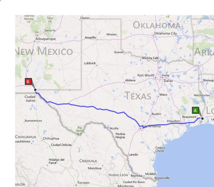
Route  --  The basic route Greg selected is starting near his home in south Florida, to Junction, TX, to Tucson, AZ back to Junction, then on to Ely, NV for the start of the "Poison" Rally  Over 90% of the route are on Interstate highways with the remainder on major US roads.  State Road Conditions:  FL, AL, MS, LA, TX, NM, AZ, NV

Ride Pace -- The key to successful long distance riding is a steady pace.  Greg will strive to maintain a consistent ride pace based on the legal speed limits, as adjusted for the flow of traffic and road conditions.  The ride pace takes into account time used for riding, pit stops and rest stops.  Good intel about current weather, ongoing construction, traffic and other issues will affect pace and navigation.   Greg has committed to a mandatory 4 hours of quality sleep each 24 hours, in a motel, at Junction, TX  (See -- Fatigue and Motorcycle Touring

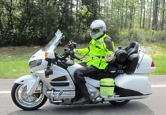
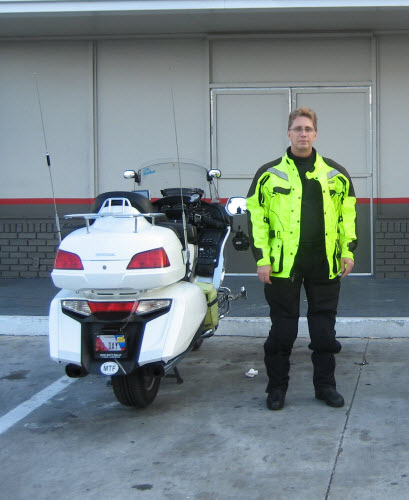
Preparations: Like many in the LD community Greg keeps his motorcycle and gear it rally trim.   Greg whet through a major upgrade of his gear and equipment prior to the 2013 Iron Butt Rally.  Your can see the preparations Greg made to his Honda Goldwing, "The Machine"!  Things Greg did specifically to prepare for this BBG Trifecta + are listed below.

  • New Olympia AST 2 Hi-Viz jacket
  • New boots
  • New deerskin gloves
  • New LDComfort tights and top
  • Cleaned Aerostich AD1 riding pants
  • New tankbag setup, may mount a Microsoft Surface with GPS antenna
  • Changed air filter
  • Changed sparkplugs
  • New helmet faceshield and sun visor
  • Integrated the audio from the Garmin 2797 into the Gold Wing’s intercom system so I can hear the audio along with other GPS’s and radar detector and cell phone
  • Updated the maps on the GPS’s
  • Cleaned the Aerostich Hi-Viz tank panniers
  • New tires
  • Changed oil and filter
  • Changed rear gear lube

About the Rider:  Greg is regarded in the long distance community as a specialist of the BunBurner Gold, IBA challenge ride.  He already has 2 BBG Trifectas to his credit.  His riding adventures are number 1 on the Top Ten All Time SpotWalla Trips.   Listed below are Greg's IBA certified BBG challenge rides:
  • 2 Time finisher of the Iron Butt Rally with a top 10 Gold Podium finish in 2013
  • 2 BunBurner Gold Trifecta
  • 1 BunBurner 3,000
  • 13 BunBurner Gold 
Greg is committed to safe long distance riding.  He rides within his limits, the limits of his motorcycle and the limits of the riding environment.  He knows the risks of exceeding those limits and is committed actively managing the risks.   He is a well conditioned and an experienced long distance motorcycling athlete who appreciates training at the edges of his performance limits. 
So, if you want to learn more about long distance riding?  --  See the Iron Butt Association "Archive of Wisdom"